- Market Insights of Services that Use Geolocation
- Technologies that enable geolocation functionality
- What tech tools will help you to create a location-based app?
- How to make a location-based app: A step-by-step guide
- Mobile Apps that Benefit from Geolocation Feature
- Costs of location-aware mobile project
- Takeaway
Most modern applications use location features to improve performance. You’ve probably come across an app, like Apple Maps, displaying the ‘Allow AppX to access device’s location’ notification. The geolocation functionality takes effect once you click on the ‘Allow’ or ‘Enable’ option.
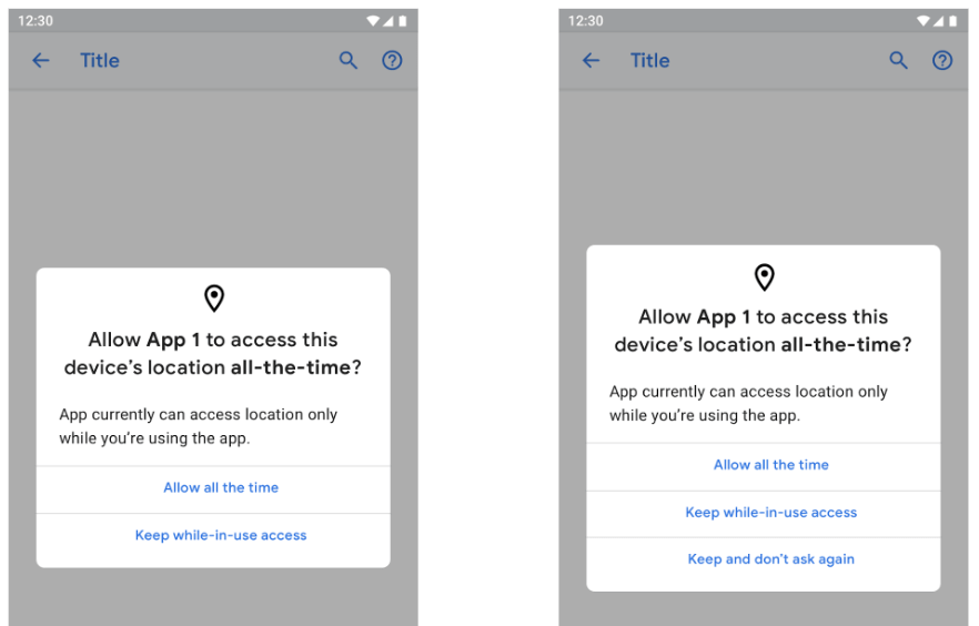
[Sample permission request from Android]
Some world-renowned companies that use geolocation-reliant apps for optimum functionality include Airbnb, UberEats, and Foursquare. All these location-based apps can detect objects, buildings, services, and businesses around you. Even the dating app, Happn, uses location-based technology to match people.
In the same manner, geolocation is also an integral component of apps focused on logistics, delivery, and other service industries. The APP Solutions utilizes these location-based functionalities in applications like Alfred Ibiza, HYPR, and Nuwbii.
In this article, you will discover an extensive exploration of the processes involved in creating and marketing great location-based apps. You will also discover the inner workings of location-aware apps and how to integrate them into your software development.
HOW COLLABORATIVE LOGISTICS SOFTWARE IMPROVE SUPPLY CHAIN VISIBILITY
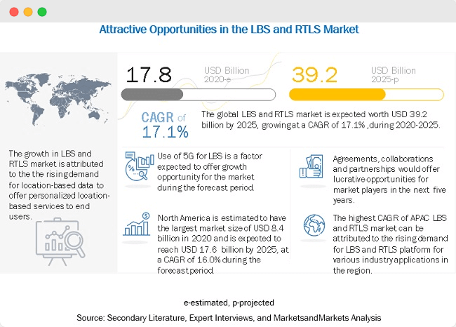
Market Insights of Services that Use Geolocation
The COVID pandemic has affected geolocation-based industries like logistics and tourism. Every company or management team is now looking for options to keep their consumers happy. But despite a great decrease in consumer activity, companies are adapting to modern methods of managing the lockdown regulations.
These adjustments involve using geolocation apps like the Apple Mapkit to bridge the gap between businesses and retailers. At the same time, healthcare services now rely on convenient geolocation services and platforms. For example, patients can find a doctor near them with a certified medical app.
According to MarketsandMarkets, the location-based services (LBS) and real-time location systems (RTLS) market will experience a 17% compound annual growth rate within the next five years. Professional projections have determined the current market value to be around USD 17.8 billion in 2021.
This number is expected to increase to USD 39.2 billion by 2025, which signifies an estimated revenue growth increase of 50%.
MONOLITHIC VS MICROSERVICES: CHOOSING THE ARCHITECTURE FOR YOUR BUSINESS APP
Furthermore, these estimations also consider the proliferation of apps that function better with geospatial data. Also, social media applications and user-oriented software like WhatsApp will boost the location-based services market significantly.
Technologies that enable geolocation functionality
Any location-based mobile app can only function with up-to-date map and location services. For more accurate geolocation, you need to implement several technologies. Here are some great additions to improve your geolocation services.
The term ‘GPS’ means Global Positioning System — a satellite navigation technology that provides data on geolocation and time. The most recent GPS technology offers accurate geolocation data within a few meters. You can now download navigators with built-in GPS coordinates.
WHAT TECH STACK TO CHOOSE FOR YOUR PROJECT
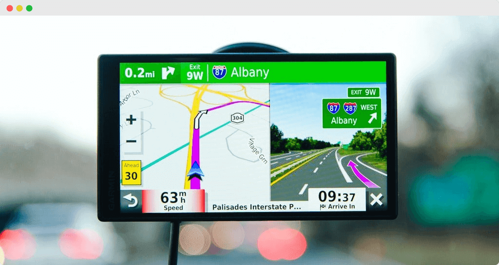
[A Car’s GPS Display: The New York Times]
Cellular ID (identification) is an essential component of geolocation because it is unique for every device. And even in the absence of live data from the mobile device, information from cell towers can provide an approximate location. Therefore, you don’t need a WiFi connection to find your current location.
Assisted or Augmented GPS (A-GPS) is a separate system that improves the general performance of a GPS positioning technology. A combination of the Cell ID and A-GPS provides a more accurate location tracking that supersedes the performance of the standard GPS.
A geo-fence is a virtual boundary within which an app performs a simple or complex pre-programmed action. Companies like Uber use the geofencing technique. Similarly, child-monitoring software uses an adapted version of geofencing to track the movement of young children.
iBeacon is a Bluetooth-based low energy proximity sensor that transmits a unique signal from beacons to the receiver (usually an app). Eddystone is Google’s version of the iBeacon. The technology is named after the eponymous lighthouse in England.
IoT-enabled devices perform route tracking using geolocation coordinates. The IoT device can easily collect data (signals) from device sensors similar to radio antennas. This data can then be used to identify the device’s location coordinates.
ESSENTIAL FEATURES FOR A CUSTOM TRANSPORTATION MANAGEMENT SYSTEM
Consider creating a Location-aware Project?
Download Free eBookWhat tech tools will help you to create a location-based app?
The technologies mentioned above are essential to the creation of clear geolocation solutions. However, you will also need other pre-existing third-party apps with data safety features. These are often GPS applications developed to show the right elements and coordinates.
Here are our third-party service recommendations for geolocation app development.
Google Maps
You can’t discuss ‘location’ without thinking of maps, and the most famous of them is Google Maps. This app detects and shows a user’s current location with the help of geolocation functions and trackers.
Mobile applications like Uber and Lyft rely on this app for their geolocation services.
TOP AI USE CASES IN SUPPLY CHAIN OPTIMIZATION
[Google Maps: Pexels]
Google decided to combine all of its APIs into Maps, Routes, and Places. This decision simplified the integration of geolocation solutions into software development. But developers can only access these APIs with a unique authenticator key, which they can only obtain from Google administrators.
1. Maps
The Google Maps API allows the inclusion of maps to applications. Maps also ensure that you are able to change the display with an embedded panoramic view.
Functionality
- Maps SDK — this Android-based API allows the addition of data from Google Maps to your app. Maps SDK allows automatic access to Google servers, response to map actions, and downloads.
- Maps JavaScript API — this unique API allows developers to add custom graphic content on their devices and web platforms. The JavaScript API comprises four customizable map categories: satellite, roadmap, terrain, and hybrid.
- Maps Embed API — with this great API, you can add an interactive map to your website with a basic HTTP request. The Maps Embed API differs from the JavaScript API because you can customize it without any Javascript experience.
- Maps Static API — this API allows you to add any Google Maps graphic to your website without dynamic page loading. All you need is to send an HTTP request, which returns a match you can display on your platform.
- Street View Static API — this API gives you access to updated real-life representations of locations. You can embed the API as a thumbnail on your site.
- Maps URLs — this tool generates a cross-platform link that can obtain directions and display panoramic views.
2. Routes
This API allows access to accurate directions and active routes between given locations on the map. You can also use this tool to monitor real-time traffic updates about route congestion and accidents.
- Directions API — with the Google Maps Direction API, you can get directions depending on your preferred mode of transportation. The service also calculates the distance between locations via an HTTP request generated from user inputs.
- Roads API — this tool provides specific data on traveled roads, like speed limits and alternate routes.
- Distance Matrix API — this service calculates the distance between waypoints on a map and how long it will take to cover it. The Google Distance Matrix API works in conjunction with the Directions API to provide accurate estimates on departure and arrival times.
STAGES OF LOGISTICS MOBILE APP DEVELOPMENT
3. Places
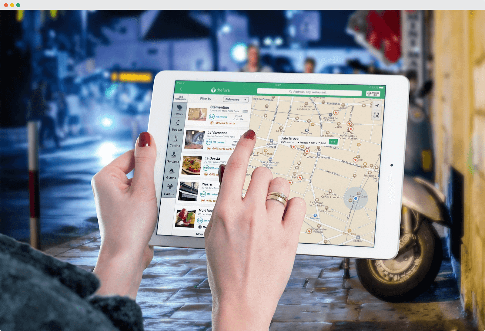
The Places API allows users access to over 100 million locations. It also enables them to find places using GPS addresses and phone numbers. The photo location finder users can also take advantage of this API for outdoor and indoor navigation.

[Person searching for Airbnb openings with a location-based feature: Pexels]
- Geocoding API — this service converts long, physical addresses into geographical altitudes and coordinates (latitudes and longitudes). In essence, the feature allows users to place a point on the app and obtain the full address.
- Geolocation API — this effective geolocation tool pings cell towers and uses the information to provide a location within a defined perimeter.
- Time Zone API — this interface allows users to find out the time zones of different locations worldwide. This API provides the time zone and the current time in UTC and day-light savings.
- Places Library — this API enables applications to search for locations and prominent landmarks. The auto-complete features provide relevant suggestions for a better user experience.
Pricing
The current Google business model features a pay-per-use system for APIs. Every business gets a recurring $200 monthly credit, which can be customized to protect against unexpected price spikes. You can also review your data usage for informed implementation.
When you purchase the Maps API, you gain access to all the components, including unlimited access to the Mobile Native (Static and Dynamic) Maps. You can go through the available freebies and product costs on the Google Maps pricing platform for developers.
THIRD-PARTY API INTEGRATION TO MOBILE BUSINESS APPS: BENEFITS, TYPES, AND A STEP-BY-STEP GUIDE
Mapbox
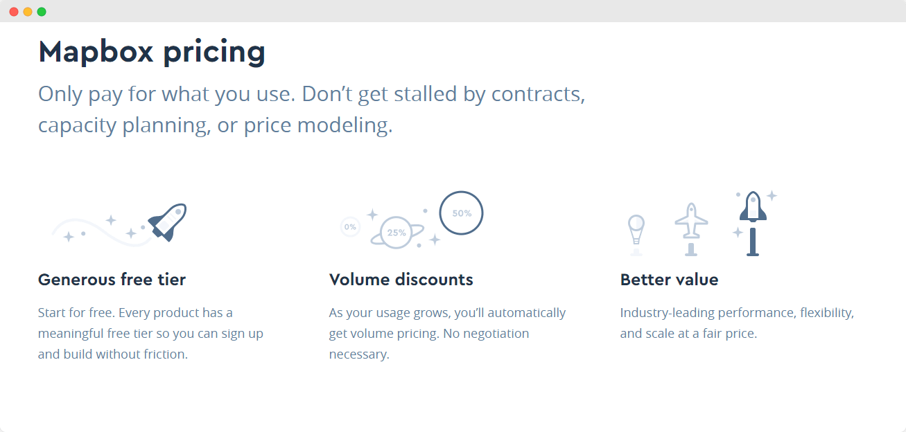
Mapbox is another map service provider and a close rival to Google Maps. Mapbox partners with Facebook, CNN, AllTrails, Shopify, and other top tech companies. If you don’t think that Google Maps fits your app, Mapbox is a rather reliable substitute.
Functionality
- Maps services — with Maps services, developers can work with customizable maps generated from multiple sources. This feature also allows the creation of dynamic and static maps. You can also choose your application’s preferred theme view: light, dark, streets, outdoor, and satellite.
- Navigation services — this tool generates accurate real-time routes for users. Navigation services also include intuitive turn-by-turn navigation and traffic-aware routing.
- Geocoding API — this API provides data on a device’s geolocation.
- Mapbox Studio — this service features an independent ecosystem for designers to create and manage geolocation data. The interface allows developers to explore their creativity to come up with fantastic map designs.
Pricing
Mapbox also utilizes a pay-per-use model, but every product comes with a designated trial period. Moreover, you also get a special discount depending on your usage. If you have less than 25k users and 50k map loads, the Maps SDK won’t cost you a cent. When you exceed 25k app users, the cost of the Maps SDK increases to $4 per mille (thousand).
Check out the complete Mapbox price sheet on their website.
HOW TO BUILD A REAL ESTATE WEBSITE LIKE ZILLOW
TomTom
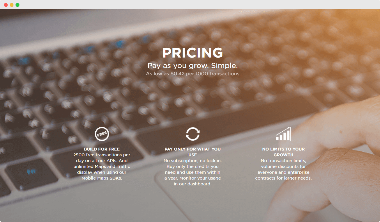
TomTom is another location-aware tool for the creation of location apps. This less popular alternative to Google maps is also a viable substitute. Let’s find out the specific tools and services available. TomTom has worked with Microsoft, Michelin, Precisely, Trivago, and other companies around the world.
Functionality
- Maps API — the Map Display API offers access to the Raster and Vector API. You can choose the preferable end-point that is most suitable for your application.
- Routing API — this API is an advanced routing engine for users. The tool generates up-to-date info on routes.
- Search API — this feature works in conjunction with Foursquare to return info about locations based on search queries. The Search API also uses pinpoint geocoding technology for app location-based features.
- Traffic API — this API combines real-time and well-known heavy traffic data for improved location detection.
Pricing
TomTom uses the same pay-per-use model as Google Maps and Mapbox. After exceeding the free 2500-transaction limit, the model changes to ‘pay as you grow.’ For more details on TomTom’s pricing policy, visit their website.
Although the Mapbox app may not have the same reach as Google Maps, it is quite impressive and easy to enjoy. TomTom remains a close competitor, providing cheaper app location-based services to businesses in Europe and the rest of the world. It is only a matter of time before they become some of the best high-end tech services in the App Store.
DOG WALKING APP DEVELOPMENT GUIDE
The APP Solutions Experience: Success Story
Alfred Ibiza is an on-demand delivery mobile app that connects restaurants, stores, couriers, and customers in Ibiza. The app allows customers to order from restaurants, pharmacies, and supermarkets, listed on the platform.
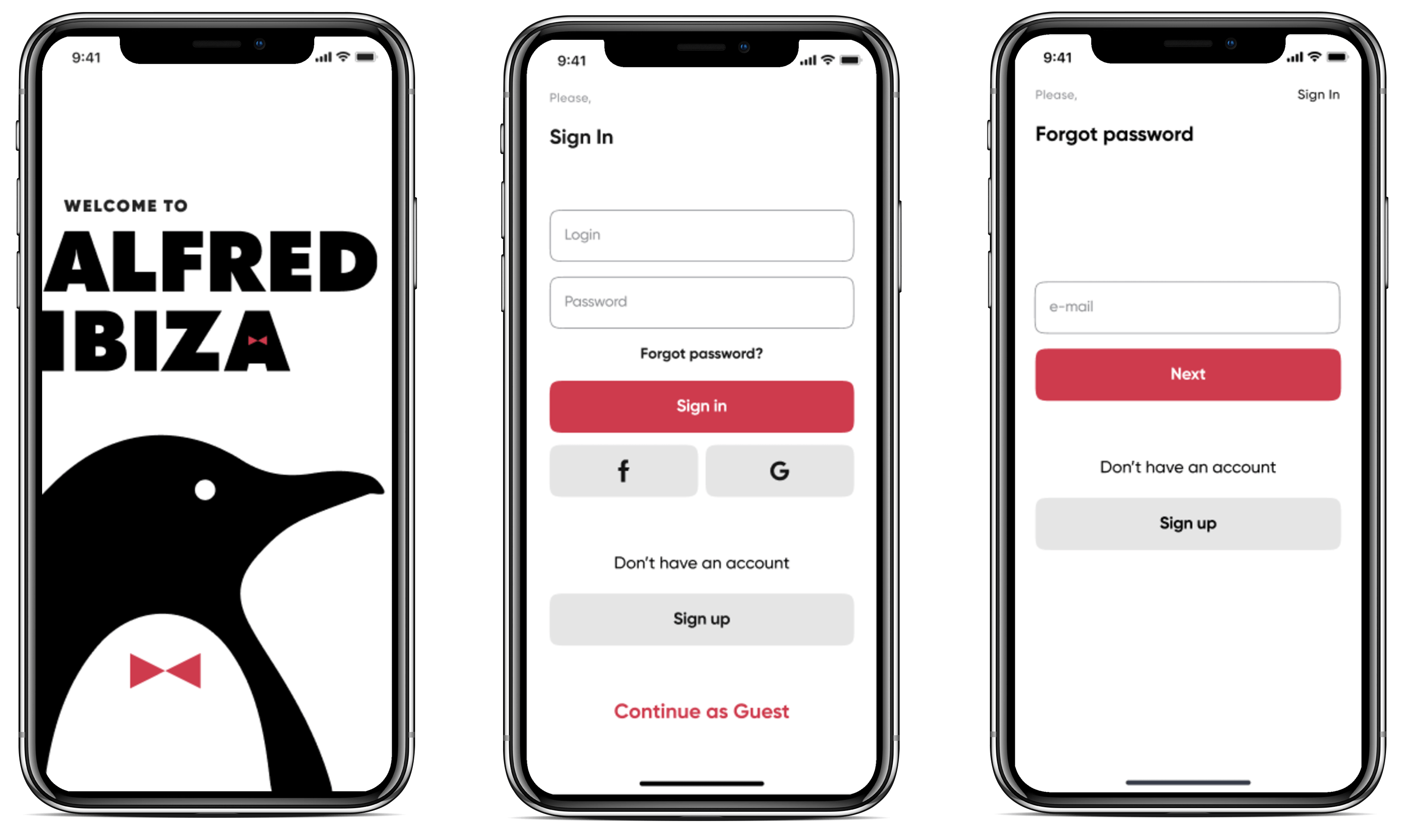
Our main goal for the Alfred Ibiza project was to build a platform that would simplify ordering and delivering products on Ibiza island and help party goers to receive their orders on time. We wanted the platform to be equally useful for business owners, couriers, and customers.
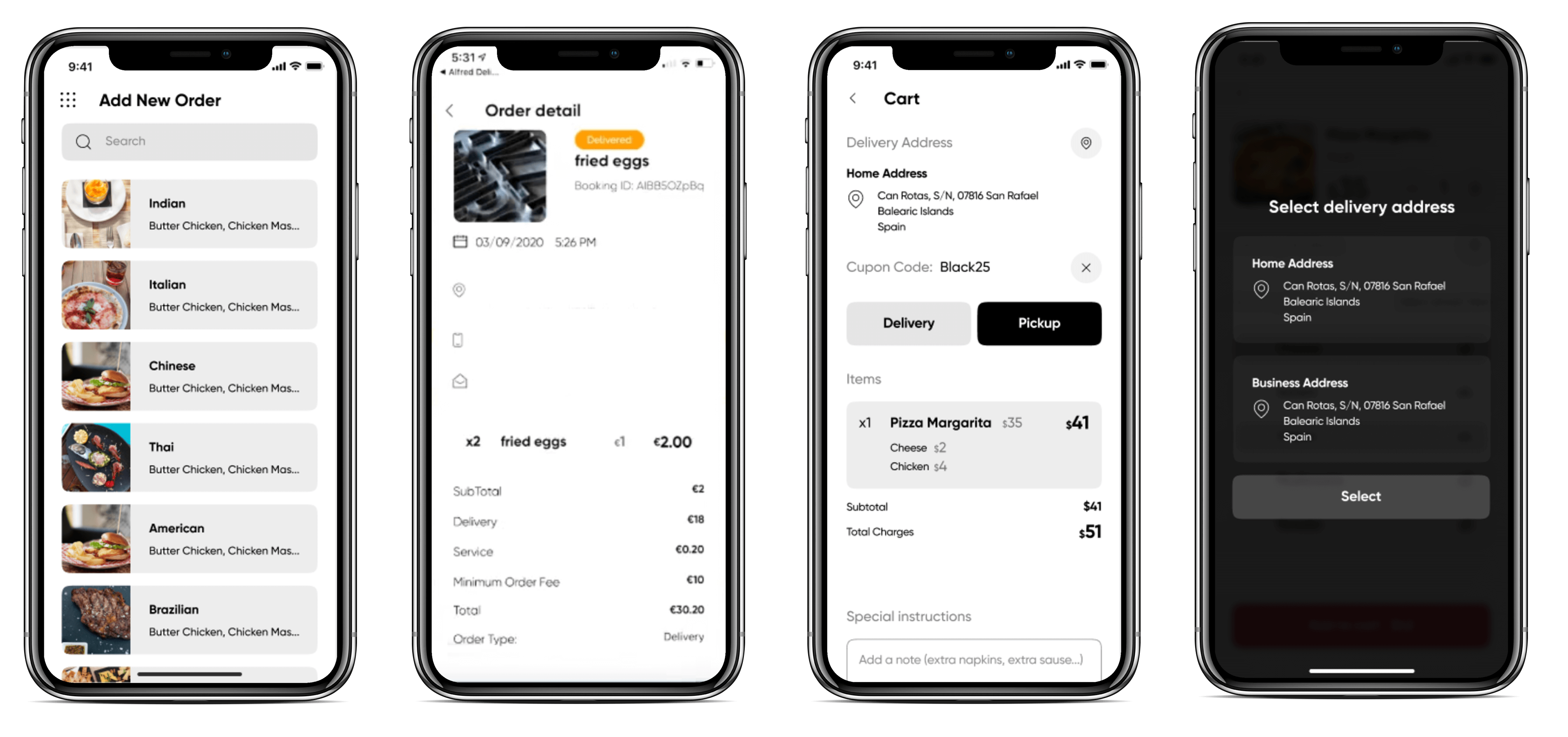
We managed to develop the Alfred Ibiza platform within just three months, at a total project cost of $70,000, 50-60% cheaper than the average development cost of a food delivery app.
The platform includes an app for customers, couriers, an admin panel for restaurants with only necessary functions. Besides this, we also developed a marketing landing page to promote the Alfred Ibiza platform.
You can find more fascinating stories in our portfolio, and now we will go back to the theory.
SWIFT VS REACT NATIVE: WHICH ONE IS BETTER TO CHOOSE WHEN DEVELOPING YOUR APP FOR IOS
How to make a location-based app: A step-by-step guide
Creating a location-based app is a systematic plan that involves several stages, including testing, research, wireframing, and consumer outreach. This well-structured process focuses on identifying the main factors that enable your business to maintain market dominance.
Let’s go through some of the key factors and steps involved in creating a location-based app.
Step 1. Research Your Idea
The business analysis offers insights into current consumer trends to be considered when developing an app. Don’t forget to analyze your competition to enhance your set objective.
Also, arrange every finding with a story map based on priority and complexity. These techniques are efficient when sharing insights on every given task within the ideation chain.
Which location-based service is in demand? How will the app address users’ requests?
If you don’t address the issues before developing a location-based app, you will struggle to create an application with market relevance and quality.
Therefore, research the market and competitors to look at the market potential and figure out how to make the app better.
Step 2. Create a Wireframe of your geolocation app
UX app design and wireframing are essential for location-based app development. You always want to visualize the app on a screen and fix possible functionality issues before the app goes into the development stage.
To bring your idea to reality, you and your app development team need to put your idea down on paper and develop a storyboard. Subsequently, the storyboard, wireframes, and mockups will help to determine the geolocation app’s potency and market performance.
EDGE COMPUTING EXPLAINED WITH EXAMPLES
Step 3. Prove GPS app concept with MVP
A proof of concept (MVP) is essential for developing location-based apps. This proof of principles shows that the app may become a viable product. Therefore, create a minimum viable product for your business idea. This concept will help you to target any reliable source of investment. Similarly, you can give the public the chance to know the project’s objective.
Step 4. Create a feature-rich map-based app
After receiving user feedback, you can start the second development stage and add other important features to your app. Always pay special attention to consumer concerns and suggestions.
For location-based apps, the main features should always provide the best advice on objects within a given radius. Remember to add the account creation function and other basic features.
You can add extra steps to address issues like marketing and sales, but these four key tips are indispensable when working on a geolocation app.
By following these procedures, you will build a location-based app with high ratings. And soon enough, you can start competing with the best software companies in the world.
NODE JS VS. REACT COMPARISON: WHICH TO CHOOSE FOR YOUR JS PROJECT?
Mobile Apps that Benefit from Geolocation Feature
In the modern tech world, almost every app uses geolocation features for a better user experience.
Let’s check out the industries that witness an extensive application of these geolocation features.
Taxi-hailing
Built-in GPS modules in mobile devices define the user’s location so that the taxi-hailing platform can calculate the price of a ride. The platform also uses simple GPS coordinates to track a driver’s location and ensure that passengers can see when the cab arrives.
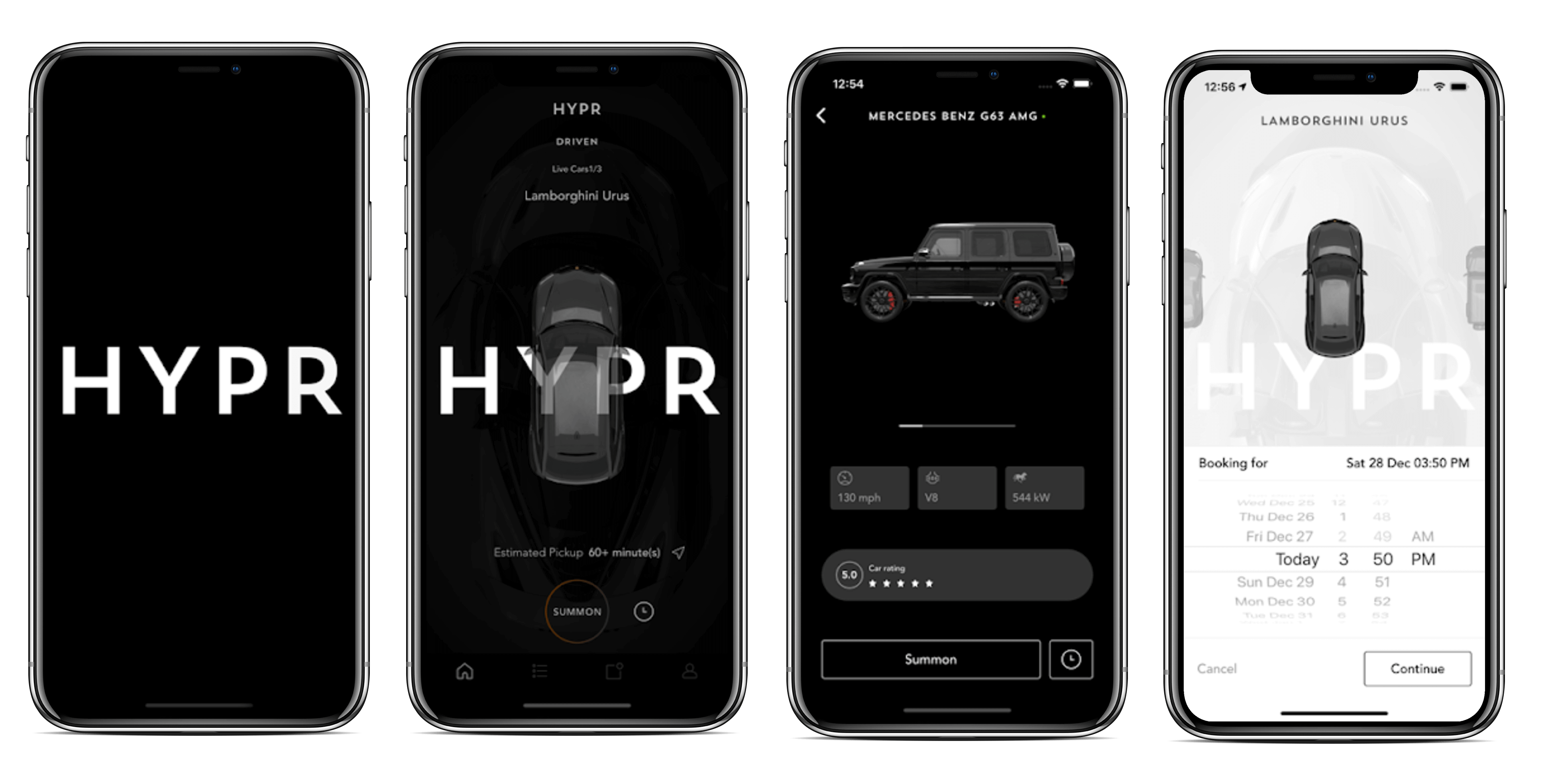
[The APP Solutions Project for HYRP]
Taxi-hailing apps also use geolocation functionality to navigate the driver to the destination during the ride. Moreover, ride-sharing apps also use push notifications to notify cab drivers of passengers going in the same direction.
Maps and navigation
ServiceS created to help users navigate the terrain, such as Google Maps, Waze, as well as a variety of compasses, schedules of urban transportation, local travel guides, and astronomy, utilize geolocation.
PUBLIC VS. PRIVATE VS. HYBRID CLOUD COMPUTING
Landmarks and Place recommendations
Recommendation apps gather location data from your devices and suggest locations around you or within a specified perimeter. Such location apps target nice hangout locations based on reviews from other consumers.
Companies like Booking and TripIt optimize their services based on location. You can set your current location and obtain access to a local travel guide within the city. In addition, you can view various photos of locations added by other users.
More so, a travel app like TripAdvisor uses basic matching algorithms to arrange the users into groups based on a common interest. Nowadays, you can even leave a comment or message on any upload.
Weather forecast applications
Apps like Yahoo Weather and Weather Underground use geolocation data to increase usability and skip a few steps between the consumer and the product. You have such apps or widgets on your smartphone for sure.
The core working principle of these weather apps involves detecting user location and providing data on the weather conditions. These apps also display forecasts from the nearest geolocation.
There is one more interesting fact about them: Weather apps lead the location-based apps category by about 65%, compared to 35% by social networking apps.
HOW TO OUTSOURCE MOBILE APP DEVELOPMENT
Food delivery for family and friends
Apps like Uber Eats, Bolt Food, and Glove use geolocation technology to detect the user’s location and map the closest restaurants to the device. At the same time, they calculate the estimated time needed to order and deliver the food to the user’s unique address.
Also, food delivery mobile apps allow users to save their favorite addresses, which reduces the amount of data processed by the geolocation server every session. You can also leave a rating at all the restaurants you visit, allowing other users to access that same info.
Doctor-on-demand
Doctor-on-demand apps detect the user’s location and recommend the closest certified doctor. Apps like Calmerry collect patient location and personal data and use the info to optimize doctor recommendations based on proximity.
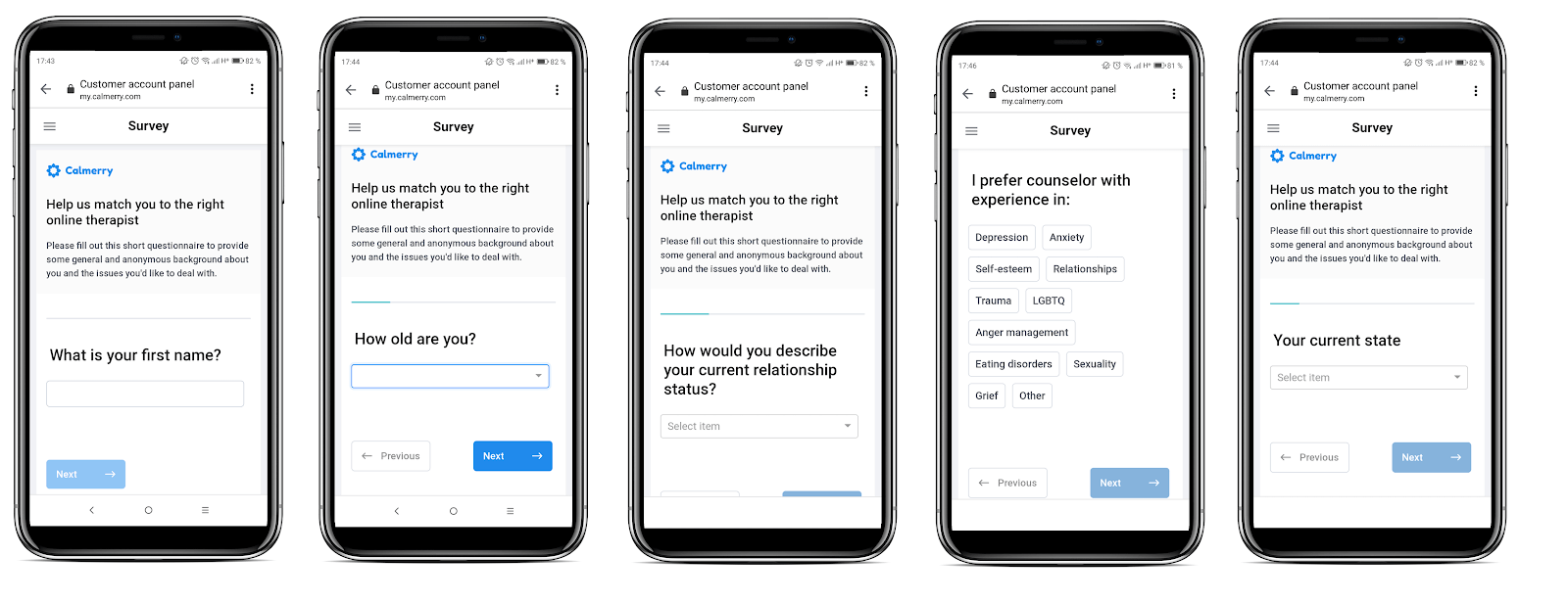
[The APP Solutions Project for Calmerry]
The app allows only certified therapists and medical practitioners to register as consultants on app. Moreover, these apps use transparency and data safety protocols to protect user info when you register for consultations.
Social networks and dating apps
Social networks and dating apps are location-based applications. Facebook and Instagram use geolocation to target consumers with native ads. You can also monitor ‘events near you’ on Facebook and Twitter.
Similarly, Tinder also uses geolocation technology to match users according to their location. In the same manner, Happn maps users “with whom you have crossed paths” and recommends them as potential ‘crushes’ to users.
HOW TO MAKE AN APP: LIFE CYCLE OF MOBILE DEVELOPMENT
Community applications
A community app is similar to a social network, but the only difference lies in the extensive reach and general functionality. Location-based apps like Localmind, QuePro, and Nextdoor bring people together in their neighborhood for social and political initiatives. They also connect people with local experts in every area of human endeavor.
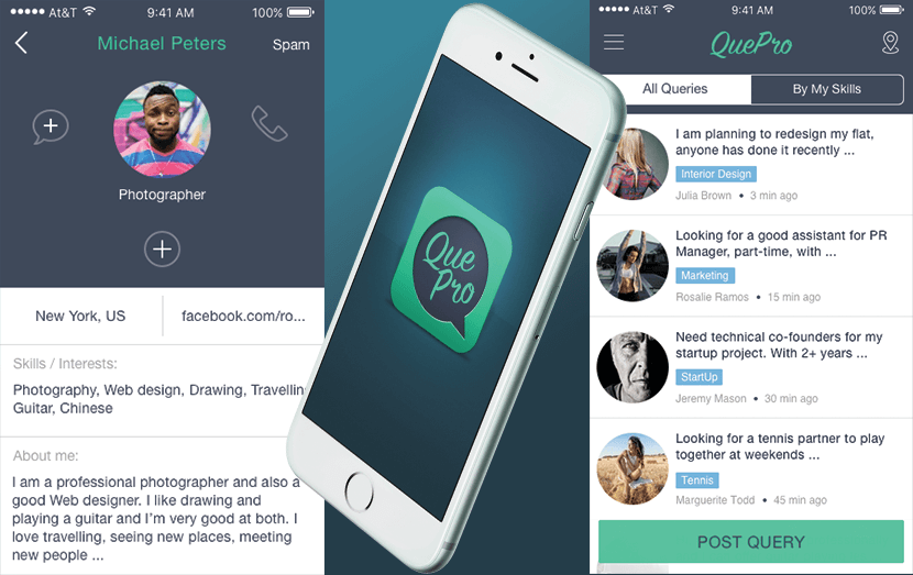
[The APP Solutions Project for Que Pro]
Health and lifestyle
Location-based apps use GPS coordinates to detect user location and recommend running routes for joggers. Nowadays, these apps are synced with basic fitness trackers, allowing the user (jogger) to monitor data on their mobile devices.
At the same time, the trackers monitor how far you travel while plotting your movements on a display screen. This map data is collected from satellites.
Examples of location-based apps for running, workouts, and general fitness include Nike Run Club and Map My Run.
Camera Apps
Whenever you take a picture with your camera app, the phone registers the metadata. This feature is embedded in the device’s operating system. The specific location is included in the metadata.
So, creating a metadata-enabled camera app will offer a solution to hours of fruitless searches for locations.
HIRING A DEVELOPER FOR YOUR BUSINESS: A SIX STEPS GUIDE
Shopping and recreation
Online shopping and e-commerce platforms take advantage of your phone’s GPS coordinates to recommend services near you.
For instance, you can get IKEA recommendations from the company’s nearest store. These types of location-based apps also allow on-demand delivery to any destination of your choice.
News
News apps also use location tracking systems to deliver articles to readers. These apps filter your interest and recommend certain news items you might want to read. And most importantly, they allow you to localize ‘Breaking News’ push notifications on your device.
Although most of these location-based apps can drain your battery, they are the perfect solutions to current user concerns. Moreover, bugs can leave you stranded and users’ personal info open to external attacks. So, invest in the right human resources when building a geolocation app.
Trends in Location-Based App Development
Keeping up with trends in location-based app development has become a game changer for many companies in the industry as they face one of the toughest competitions. According to studies, those who have managed to incorporate emerging technologies have successfully met the ever-changing needs and expectations of clientele and secured their position in the market, coming off as a thought leader who can be trusted. Here are the key trends that companies adopted this year:
Advanced geolocation tech stack. GPS, A-GPS, Cell ID, iBeacon, and IoT have opened great opportunities for serving clients across the globe and providing them with an accurate user experience.
Accessible and modular APIs. As APIs are getting increasingly popular among companies because they extend their product functionality and boost efficiency, accessibility concerns arise. Many vendors, like Google Maps, Mapbox, and TomTom, encourage companies to improve their product’s accessibility, responsiveness, and inclusivity.
Adaptation to wider application. Many solutions are created to meet the multiple needs and demands of the market. For example, geolocation finds its place not only in the delivery sector but also in the e-commerce, fitness, and medicine industries.
Costs of location-aware mobile project
App ideas are free, but you need to understand how much you can make from the project and the potential cost of production.
How much will your geolocation app cost?
There is no definite price tag for your geolocation app project because the cost of developing a GPS project varies. If you need to integrate geolocation functionality into an existing app, it would not cost much. But when building everything from scratch, you will need to extend your budget significantly.
OUTSTAFFING VS. OUTSOURCING VS. MANAGED SERVICES: DIFFERENCES AND BENEFITS
Ready to calculate the GPS app costs?
Use free project cost calculatorAccording to estimates from developers at The APP Solutions, you can fully integrate geolocation functionality within 5-10 hours using third-party API. But when creating an app design for location apps or developing a particular app functionality that requires geolocation data, the price increases remarkably.
Takeaway
In conclusion, geolocation technology is the future of app and software development. Choose the best location-based application option that fits your budget and consumers. You can always use the same models and source code as established companies like Uber and Booking.
Furthermore, you can integrate your preferred geolocation technology or combine more than one for more accuracy. GPS modules and Augmented GPS work in tandem for error-free detection of latitudes and coordinates.
HOW MUCH DOES IT COST TO DEVELOP AN APP: DETAILED FEATURE BREAKDOWN
Don’t leave out interesting features in your app. Use account creation, file exchange, and messaging to attract more users. Moreover, you can always follow the 4-step approach recommended by our experienced app developers.
Create a clear plan to keep users updated via email. And make sure to write posts and informative articles to keep them updated.
Ultimately, if you need assistance with your app, you can outsource the project to us. Our experts can walk you through the entire process, from conceptualization to full product launch.